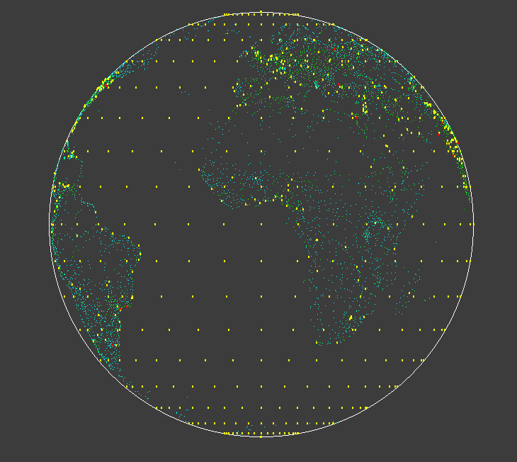
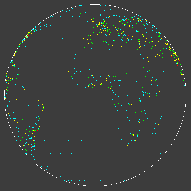
Projections of the Earth's globe on screen.
Byte magazine published an edition centred on graphics and map projection. Back then I didn't have acceess to an adequate computer, nor to the necessary data. It stayed on my back-burner as a 'to-do'. I kept that copy, even though I threw away most of the other months and years.
In the last year I experimented with scanning text and OCR-ing it to recover text. The ( early) BASIC had been printed on a dot-matrix printer for Byte, and not with 100% clarity. However I was able to make a good enough version to be able to correct the OCR and edit to the more modern Liberty BASIC. And remove all those line numbers, labels, and capital letters! I also found that the published version had some errors and contradictions in the published sub-routines, and confused radians and degrees.
Nowadays you can easily download lat/lon data off the 'net. I found a file of all large population centres in the world, and edited out the un-needed extra columns, leaving me a text file of lat/lon/pop'n data.
It took quite while to sort out, but I'm pleased with it so far. By looping round looking from different longitudes I was able to make a nice animated GIF. The cies are coarsely color-coded for population size.
Now to tackle different projection geometries!
It has also been fun looking through the magazine- the old adverts for early personal computers are very evocative. And I found also, even older, the first language manual I tried to understand- Titan Autocode on Cambridge University Atlas in 1967.
    nomainwin

    WindowWidth  =900
    WindowHeight =740

    graphicbox #w.g,1, 1, 898, 738

    open "World Views" for window as #w

    #w   "trapclose quit"


    global pi:    pi    =3.14159265
    global twoPi: twoPi =2 *pi


    R   =300    '   RADIUS OF GRAPHIC IN SCREEN PIXELS


    'L0  = 80    '   LONGITUDE OF OBSERVER IN DEGREES.
for L0  =0 to 360 step 10
    #w.g "cls ; goto 450 350 ; down ; fill 60 60 60 ; size 1 ; color white ; circle 300 ; flush"
    #w.g "color white ; size 1 ; down"

    '   Add loop through range of P and LA to generate screen grid of lat /lon
[grid]
    for lat =-90 to 90 step  10 '   BOTH IN DEGREES. EAST OF MERIDIAN +ve. NORTH +ve.
        for long = -180 to 180 step 10
            L   =long
            P   =lat
            '#w.g "set "; int( 450 +2 *long); " "; int( 350 +3 *lat)
            gosub [findPoint]
        next long
    next lat

    #w.g "flush"

[dataShow]
    #w.g "color 180 180 100 ; size 2"

    open "LatLon2.txt" for input as #fIn

    line input #fIn, g$

    for k =2 to 7343
        line input #fIn, g$
        L   =val( word$( g$, 2, ","))
        P   =val( word$( g$, 1, ","))
        pop =val( word$( g$, 3, ","))
        gosub [findPoint]
    next k

    close #fIn

    #w.g "flush"
    #w.g "getbmp scr 1 1 898 738"
    bmpsave "scr", "globe-" +right$( "000" +str$( L0), 3) +".bmp"

    scan
next L0

    wait

[findPoint]
    ' SUBROUTINE TO COMPUTE MAP COORDINATES FOR ORTHOGRAPHIC EQUATORIAL PROJECTION.

    ' THE FOLLOWING VARIABLES MUST BE DEFINED BEFORE THIS SUBROUTINE IS CALLED:
    '   P  IS THE GEOGRAPHIC LATITUDE         IN DEGREES OF THE POINT BEING CONVERTED.
    '   L  IS THE GEOGRAPHIC LONGITUDE        IN DEGREES OF THE POINT BEING CONVERTED.
    '   R  IS THE RADIUS OF THE FINISHED MAPS IN PIXELS.

    ' THE FOLLOWING VARIABLES ARE COMPUTED BY THIS SUBROUTINES
    '   S  IS THE OFF-SCALE FLAG.             S =0 MEANS ON-SCALE S =1 MEANS OFF-SCALE.
    '   R1 IS TEMPORARY STORAGE.
    '   X  1S THE MAP X-COORDINATE IN PIXELS.
    '   Y  IS THE MAP Y=COORDINATE IN PIXELS.

    S   = 0

    ' ROTATE THE GEOGRAPHIC LONGITUDE OF THE POINT FROM THE DATA BASE TO REFERENCE IT TO THE MAP CENTER LONGITUDE
    '       AND CONVERT TO RADIANS.
    L   = ( L -L0) *pi /180
    P   =   P      *pi /180

    ' NORMALIZE THE ROTATED LONGITUDE BETWEEN ~180 DEGREES AND +180 DEGREES (-PI AND +PI)
    IF L >pi           THEN L   = L - twoPi
    IF L <( 0 -pi)     THEN L   = L + twoPi

    ' IF OFF-SCALE (OUTSIDE THE RANGE FROM -P1/2 TO +pi/2 SET FLAG AND RETURN
    IF L  <( 0 -pi /2) THEN S = 1: RETURN
    IF L  >(    pi /2) THEN S = 1: RETURN

    ' COMPUTE THE MAP COORDINATES FROM THE GEOGRAPHIC COORDINATES.
    '       L IN RANGE -pi/2..pi/2    P IN RANGE -pi/pi.
    R1      =  R * sin( ( pi /2 -abs( P)))

    X       = R1 * sin( L)
    Y       =  R * sin( P)

    select case
        case pop >1E7
            col$ ="red":    size =3
        case pop >1E6
            col$ ="yellow": size =2
        case pop >1E5
            col$ ="green":  size =1
        case else
            col$ ="cyan":   size =1
    end select
    #w.g "color "; col$
    #w.g "size "; size
    #w.g "set "; int( 450 +X); " "; int( 350 -Y)
    RETURN

    END

sub quit h$
    close #h$
    end
end sub